


~~* The Singing Falls Stream Restoration Project *~~
 ϕ
ϕ
~~* Statement of Proposed Action (SOPA) *~~
~~*The Tiller Ranger District welcomes your comments on the Joe Hall Watershed Restoration Project.*~~
Inspired in 2004 by the return of coho salmon to Joe Hall Creek for the first time since the late 1950s, the Tiller Ranger District, Umpqua National Forest have been invited by adjacent private landowners to work cooperatively in restoring and enhancing salmon and trout habitat in the Joe Hall watershed.
Fish production in the 3,700-acre Joe Hall watershed is limited by several factors including increased turbidity, increased water temperature, decreased water quantity, and decreased habitat complexity. These problems can be attributed to past management activities on both private and public lands. During the 1950s large wood along Joe Hall Creek was harvested or 'cleaned out' of the stream channel.The combination of large wood removal and subsequent upslope harvest, coupled with severe rain-on-snow events in 1964 and 1974 resulted in channel down-cutting, channel straightening, loss of spawning gravel and habitat simplification.
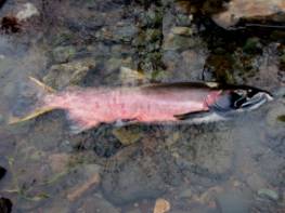
Spawned out male coho salmon from Joe Hall Creek.
The proposed project is consistent with the objectives of the Umpqua National Forest Land and Resource Management Plan, as amended.The Umpqua National Forest Watershed Restoration Business Plan (2000) and the Watershed Restoration Business Plan - Update (2003) and Elk Creek Watershed Analysis (1996) have identified restoration of aquatic habitats utilized by salmon and trout as a high priority projects for the forest.In addition, the Wyden Amendment (Public Law 105-277, Section 323) specifically allows the Forest Service to work in partnership on projects that benefit resources on both public and private lands if the project's goals are to restore and enhance watersheds.This project provides an opportunity for significant aquatic habitat restoration in Joe Hall Creek and the Elk Creek watershed.
~~*What actions are proposed?*~~
The Joe Hall Watershed Restoration Project proposes to restore aquatic and riparian habitat along approximately 2.8 miles of stream channel within the Joe Hall watershed. This will be accomplished through a variety of methods including instream structure placement, riparian fencing and stock tank placement, blackberry removal, riparian planting, thinning of conifers, well placement, culvert replacement, road improvement and the stabilization of the Joe Hall landslide area .These activities will occur on both private and public lands.
Instream structures will be constructed using large woody material and boulders. Approximately 125 unmerchantable, blow-down trees, with rootwads attached, will be hauled from upper Joe Hall for instream use.In addition, 20 logs “bridging” the creek and 35 trees within the riparian reserves will be added to the stream channel. Several car bodies located within the stream channel and on the stream bank will be removed.
Riparian vegetation management will include fencing, conifer and hardwood planting, mechanical removal of blackberry, and conifer thinning.

Sediment delivery to the stream channel along a portion of the Joe Hall landslide.
Stabilization of the Joe Hall landslide will occur by installing drainage, removing material to reduce the slope on the toe of the slide, and planting willows.On the upper end of the landslide, drains may be installed. On the lower end drains will be constructed to dewater and stabilize the slide. The lower toe slope will be recontoured to reduce slumping into the stream channel. The landslide will be planted with willow stakes and waddles to stabilize and naturalize the slope.The area will be planted with ground cover to minimize surface erosion.
~~*How can you participate?*~~
This proposal is available for 30-day comment. Following review of specific substantive comments, the Responsible Official will determine the appropriate level and method of analysis needed. Any comments you submit will be used to help define and develop issues, mitigation measures or alternatives.To be most helpful, please submit comments by March 7, 2006. Comments may be submitted in writing to the Tiller District Ranger or by email to Calib Baldwin (ctbaldwin@fs.fed.us).
Tiller Ranger District
District Ranger
27812 Tiller-Trail Highway
Tiller, OR 97484
Attention: Joe Hall IDT Leader
~~*Overview Map*~~
A map of the proposed project (scoping map) with a view of the location of the proposed stream enhancements, large wood sources, land slide, topographical information and other pertinent information can be found here
Stream Index
top


