

~~* The Singing Falls Stream Restoration Project *~~
 ϕ
ϕ
~~* Why Stream Restoration in Joe Hall Creek? *~~
The following is a synopsis of Joe Hall Creek derived from the Army Corps of Engineers permit application produced by C.T.Baldwin, . Calib Baldwin is a fisheries biologist of the Tiller Ranger District of Umpqua National Forest. He was the team lead for getting the project done.
Physical and Biological Characteristics of Joe Hall Creek
Joe Hall Creek is a 3rd order stream in a watershed that drains ridges up to 4000 feet in elevation. The confluence with Elk Creek occurs at 1400 feet elevation. Most of the watershed is within the transient snow zone and receives up to 55.5” of precipitation per year between October and June (Umpqua N.F., 1999). Rain-on-snow events combine with poor infiltration to set the stage for rapid storm runoff.
The watershed contains a core of earthflow terrain surrounded by stepp, rocky volcanic ridges. Earthflow consists of deeply weathered and altered volcanic material that consists primarily of clay. This material is structurally weak and prone to slope failures, slumping, and slope creep, but usually underlies gently sloping terrain. Water infiltration and retention within the watershed is low resulting in rapid runnoff from storm events and droughty summer conditions. Perennial springs are known to occur in the headwaters. A stream gage was installed at the crossing of Joe Hall Creek with County Road 1, just upstream of the confluence with Elk Creek (Figure 1, Project Map). Discharge estimates for annual bankfull flow are about 200 cfs. Summer discharge rates are unmeasurably low when surface flow ceases and only groundwater reaches Elk Creek.
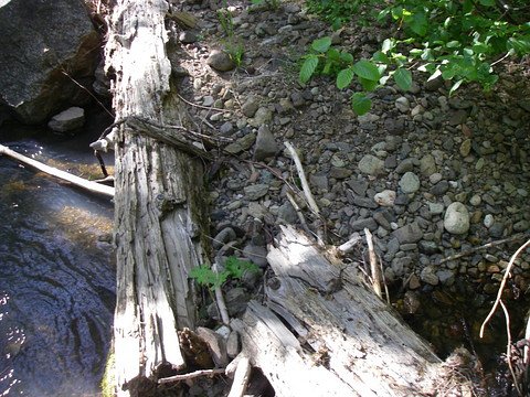
A natural log weir found up stream in the old growth forest. Note the gravel storage (right) and the scour pool (left) created by the log. Essential components for the health of “live” streams.
History of Prior Disturbance
The Elk Creek Watershed Analysis (USDA Forest Service, 1996) includes the project drainage as analysis area 04B. Dominant vegetation is of the oak woodland type. Fire suppression has prevented naturally high wildfire frequencies resulting in conifer encroachment and high tree densities. Recommended silvicultural prescriptions are to thin from below to increase fire resistance and improve the health of oak meadows, dry meadows and mature conifer stands. Thinning should be designed to reduce fragmentation of mature forest stands as well as reverse the encroachment on oak woodlands. Timber harvest on private lands utilizing regeneration harvest methods is ongoing and affects roughly half of the watershed acres.
The Elk Creek Watershed Analysis documents high road densities (5.67 mi./sq.mile in analysis area 04B). Roads intercept and concentrate natural drainage causing accelerated erosion, higher peak flows, and more rapid runoff from storms. Recommended mitigation includes culvert repair and installation, drainage dips, and other drainage features that encourage frequent dissipation of intercepted flows to promote infiltration. Harvest/thinning operations should be designed to repair road drainage and reduce road density. Planting of unshaded streams to the benefit of riparian reserves is also recommended.
Grazing is a dominant use in several watersheds along the north side of Elk Creek. Joe Hall receives some cattle use, but is more routinely used for goat and sheep grazing by private landowners along the mainstem. Noxious weeds are a problem, particularly Tansy, Blackberry and Scotch Broom. The lower reaches of Joe Hall Creek are smothered in blackberry vines such that only trees can overtop them. Plant diversity in these riparian areas is extremely low, and it is nearly impossible for new plants to become established. Willow and alder would probably dominate and stabilize the channel especially along the lower reaches.View here
Field Methods
Stream cross section and profile data were obtained using a laser level and rod with a ¼”/100' accuracy. Discharge information was developed from survey data using the WINXSPro version 3.0 cross section analyzer software. Discharge stage was measured for storm events using a mounted stage ruler near the mouth of Joe Hall Creek. Stanley Petrowski, resident at the project area, recorded water levels at least once per day and produced the plot contained in this report. Pebble counts for characterizing substrate particle size were obtained for the lower reaches of the creek using Wolman methodology. Permanent stream structures (rock weirs) were designed utilizing field measurements of distance, gradient, and elevation combined with field observations of water flow and channel condition/morphology. Stream classification utilized the methods and concepts of the Rosgen stream classification system for natural rivers (Rosgen, 1996). Large wood placements were planned by selecting sites likely to retain wood and enhance channel roughness, gravel retention, or side channel habitat.
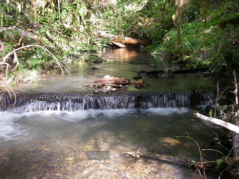
This submerged log is another example of a natural weir. Note the pool above and below the log. The pools are filled with ideal gravel deposits for making fish nests (redds).
Hydrologic Conditions, Channel Morphology, Stream Substrate and Bank Slopes
Rosgen stream classification (Rosgen, 1996), cross section data, discharge analysis, particle size survey and field observation of stream morphology provide the basis for hydrologic description in this report. The mainstem of Joe Hall Creek is classified as Rosgen type B stream channel ranging from bedrock-dominated channels (B1) to cobble and gravel dominated channels (B3 and B4). Modified channel reaches have become incised, exhibiting the near vertical banks of the F3 channel type. Channel gradient and particle size drop with proximity to the confluence with Elk Creek. Between the Forest boundary and Elk Creek, the stream gradient decreases enough to change character from a confined, relatively straight, cobble-dominated channel to a channel with non-continuous floodplain development and localized sinuosity. Despite the moderated gradient, cross sections in the lower reach (Sites 1 and 2) indicate that the channel is confined between a high native bank and the artificial berm of an abandoned millpond, losing its floodplain connectivity. In other areas, annual high flows marginally utilize available floodplain indicating continuing loss of stream function. Side channels visible in the upper reaches are generally functional because A and B channel types are durable as a result of the rock dominated substrate and banks, and because the upper reaches are generally forested. With the presence of large wood, the B channel type can retain the finer gravels and pools that make good fish habitat. Large wood is generally absent on the private lands and relatively sparse on National Forest System lands. The absence of large wood has resulted in a coarse substrate (cobbles, boulders, bedrock) and shallow pools. Pebble counts conducted on lower reaches indicate that the channel habitat with a D50 of 87 mm and a D84 of 220 mm (See attached Pebble Count Worksheet). Channel condition as classified by PFC analysis would be “Functional-At Risk” grading into “Non-Functional” for the lower reaches. In spite of this condition, salmon have successfully spawned in Joe Hall Creek in 2004 and 2005 after an absence of about 40 years.
Discharge estimates and channel dimensions are critical to designing restoration projects that conform with natural channel characteristics and flow regime. Restoration designs for the Joe Hall project used the existing channel to classify the undisturbed channel as a Rosgen B4 type. Channel dimension, gradient, and geomorphic characteristics have been designed to fit the type characteristics, observed stream size, and estimated discharge. Discharge estimates for annual bankfull flow are about 200 cfs. In most years the surface flow into Elk Creek ends in July or August. A water stage gage was installed at the crossing of Joe Hall Creek with County Road 1; water levels have been recorded daily beginning November 8, 2005 (Figure 1, Stage Data). During the winter of 2005, only one storm event out of a dozen reached a stage level greater than two feet. A late December event peaked at 2.64 feet on the 29th of the month. Pods of salmon were observed during periods when the stage was at least 0.5 feet. Estimated discharge for the annual maximum flow for 2005 is 194 cfs. At least 10 years of record is needed to support a discharge frequency rating, so bankfull levels on Joe Hall Creek have been estimated using morphological indicators (height of point bars) combined with the peak winter flow information. WinXSPro cross section analysis for three locations (stage gage station at box culvert, Site 1 and Site 2) place bankfull discharge between 136 to 203 cfs based on stages corresponding to point bar heights (the most easily recognizable morphological indicator for bankfull). Bankfull widths at Sites 1 and 2 were 32 and 50 feet respectively, with corresponding mean depths of 1.3 and 1.5 feet. Utilizing the maximum flow for 2005 measured at the gage station as bankfull, discharge would be 194 cfs and cross sectional area 53 sq. feet. For design purposes, the higher value for annual high discharge (bankfull flow) has been used. In all cross section locations the floodprone area is confined within the channel banks; cross sections 1 and 2 classify as an F channel type, even though the majority of Joe Hall Creek is a classic A or B type. This suggests a channel conversion resulting from channel modification and/or land management practices.
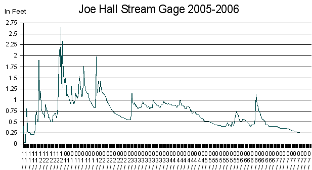
Figure 1. Stage data collected near the mouth of Joe Hall Creek. Courtesy of Stanley Petrowski.
Conspicuous channel modification has occurred on private lands. Near the mouth of Joe Hall Creek, a state highway crosses the channel via a concrete triple box culvert. Although this structure prevents any lateral channel migration, it has provided grade control that isolates Joe Hall Creek from downcutting on Elk Creek. Upstream of the highway the channel gradient is less than 2.3% for 170 feet. This relatively low gradient would lessen further if the channel were allowed to utilize its floodplain and develop additional sinuosity. In other words, the channel has been artificially straightened. Adjacent to Joe Hall Creek on the south bank is a 1950s era, abandoned millpond that is separated from the channel by a berm except at its upstream end. The mill pond may have once been a channel meander, side or overflow channel; however the area has been so reshaped that only the presence of rounded boulders and gravel suggest the possibility. Annual flood flows are unable to reach the millpond except through groundwater connection. Vertical, undercut, and eroding stream banks are common in the lower reaches and along modified tributary reaches. A prominently eroding meander bend (Site 3) is associated with lateral stream movement.
Cause of Erosion
Generally, Joe Hall Creek and its tributaries exhibit symptoms of both channel and watershed modification resulting in concentrated stream flow and elevated peak flow. Headcuts working their way up the tributaries indicate some significant disruption of stream equilibrium, and accelerated velocities are eroding the channel bottom/banks in several locations. The presence of large wood in channels allows streams to dissipate otherwise erosive energy through turbulence. Joe Hall Creek is typical of harvested watersheds in the area in that instream wood levels are low and wood size small due to past management practices.
Type and Condition of Riparian Vegetation
Conifer plantations dominate the upper portions of the watershed, providing stream shade and watershed cover. Plantations on National Forest System lands range from 30 to 14 years in age (harvested from 1976-1992). Private holdings have been regeneration harvested as recently as 2006. NFS managed stands account for 621 watershed acres (17% of watershed); forested private lands included in the Joe Hall Restoration partnership total approximately 2000 acres (54% of watershed). Mid-and lower portions of the watershed contain oak and mixed conifer woodland and dry meadows. Vegetation along the lower channel reaches is composed of small trees and brush with areas of open canopy; some of these areas have been overgrown by blackberry. Topography shades much of the main channel as it follows the base of a steep and forested mountainside. Water temperatures are dependent on shading to be favorable for fish. Temperature monitoring at the mouth of Joe Hall Creek was conducted most recently from June to September of 2005. Water temperatures exceeded the state standard of 60.8 ° F from mid- June until the channel went dry in early September. The maximum 7 day average temperature was 68.8 degrees F. Monitoring was also conducted in 1995 documenting stream temperatures exceeding state standards. Joe Hall was subsequently listed in 1998 by Oregon DEQ as impaired for summer water temperature. In 2005 a second monitoring site was located at a perennial pool below Singing Falls, on a tributary to Joe Hall Creek. Pool temperature were adequate to shelter salmon hatchlings through the summer. The maximum 7-day average was 63.3 degreesF and the duration of temperatures above the state standard was from July 7 to August 2.
Images and Temp Charts of the project
Stream Index
top


