


~~* The Singing Falls Stream Restoration Project *~~
 ϕ
ϕ
~~* Habitat Structure Engineering *~~
Welcome to the engineering pages. This section of the site is devoted to illustrating some of the salient aspects of engineered instream habitat structures. This type of work is done in habitat restoration projects that require special attention. For instance areas that are near houses, barns or roads. These specially designed structures help to control the hydraulic power of water in such a fashion that the instream conditions are not overly unwieldy during torrential winter conditions. In this way the instream habitat is more predictable in form and less likely to take on the aspects of wilderness conditions that are often formed by the whim of wind, water, downed trees, boulders and other environmental influences.
In the case of our project, the lower end of Joe Hall Creek passed right by two domestic dwellings. My neighbors, who were also collaborators in the project, wanted to rest assured that the large quantity of trees and rock designated to be placed instream for salmon habitat didn't end up in their living room on some blustery rain filled Oregon winter day. This concern is not without merit. In 1964 people were killed and houses destroyed due to flooding. Bridges and culverts were completely taken out by amassing debris that choked up the waterways. Engineered structures HELP minimize these types of events.
Neither did my neighbors want the stream to take on the meandering characteristics that might begin to further erode the stream bank and take their dwelling down stream some day. After all, the entire project is one built on the notion that we can coexist happily together with our insect, mammal and fish neighbors in the region.
The main problem needing to be solved is downcutting. When Oregon State law required the removal of woody debris from streams the fundamental premise was that woody debris formed barriers to fish spawning migrations and posed a hazard to humans and their dwellings situated in the flood planes and riparian areas of streams and rivers. Anadromous fish require woody debris to retain nesting materials, create pools and provide shelter. Once the woody debris was removed nesting materials flushed down the rivers. The once deep pools of streams disappeared and little shelter was provided from the main predators relating to fish-birds of prey.
Another significant element plays into the need for restoration work. Once the gravel and wood departed the streams, stream temperatures began to rise. Salmon and their kin require cool water temperatures to survive. Once aquatic temperatures rise above 17°C the fish become stressed, subject to disease, and the water itself loses its ability to retain usable oxygen for the fish to breath. The end result is usually small pools filled with many dozens of small dead fish belly up.
Well constructed weirs in particular do a lot to slow down the destruction of the stream. Properly engineered weirs effect the aggradation and minimize stream down cutting. This is the task at hand
As the story unfolds click on the thumbnail images to see a larger version of them. You might find it more convenient to navigate this page using your web browsers full screen mode. If the image is large enough I've made a separate display page for it. Simply click the thumbnail. Each page has a “back” button at the bottom that will bring you back here.
I've also created a hyperlinked image below as a means navigation via a “hot spot map” to specific site information. By selecting (clicking) a position number or its corresponding green dot on the map you will be able to navigated to the page pertaining to that location in the project area. Click your web browser “back” button to return to this page.

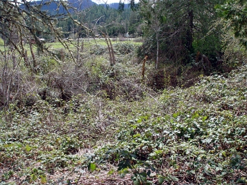 The plight of the stream-a vicious thorny brier.

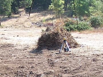 The thorny briers piled for burning.
Our first consideration is to assess the present condition of the stream. Here you can see the waterway completely covered with Himalayan Blackberries. This non-indigenous species of viciously thorny bramble originates in Europe. It produces an extremely delicious berry in abundance that lends itself to all manner of pastry baking and award winning wines. Unfortunately birds and mammals of every kind also find the berries delectable. The seeds are easily passed by waste and spread everywhere to choke out native species of plants. There is actually a stream buried in the midst of this thorn brier.
Fish, aquatic mammals and other forms of life in the riparian zone are very sensitive to herbicides and pesticides. So much so that the United States Forest Service is forbidden by law to spray within its national forest jurisdictions. Even the inert ingredients of herbicides have been known to be a severe hazard to fish. Many of the toxic compounds break down into estrogen like chemicals that mutate young fish and prevent them from reproducing.
For that reason our local watershed council recommends mechanical noxious weed removal. The above image of machine piled blackberries is directly adjacent to the berry covered stream.

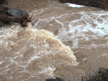
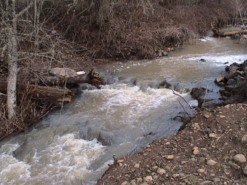
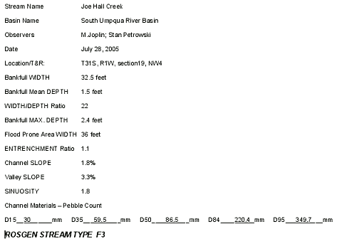
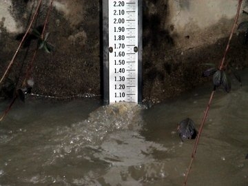 The stream gage at Joe Hall Creek and Elk Creek.


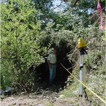
The first phase of the work consisted of gathering the data needed to estimate what the potential maximum stream conditions might be. We also seek to establish a baseline of current conditions in the hope that we will be able to estimate the impact of the habitat restoration on fundamental ecological elements of the watershed. We placed a stream gage on the down stream side of the concrete box culvert at the mouth of Joe Hall creek where it flows into Elk Creek. This gage is used to gather the depth of water and hence the volume of water flowing in the stream at various times of the year. Daily I read the gage and place the information into a data base along with the record of any rainfall.
We have diligently kept a daily record of stream flow and rain fall amounts since 2005 prior to the habitat structure building implementation phase of the project. Graphs of these records are posted here and can be viewed by selecting the graphs thumbnail above.

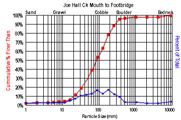
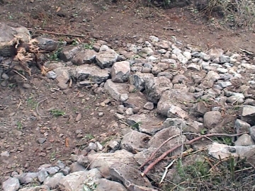
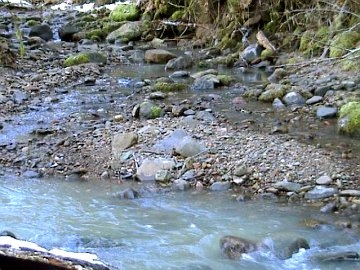
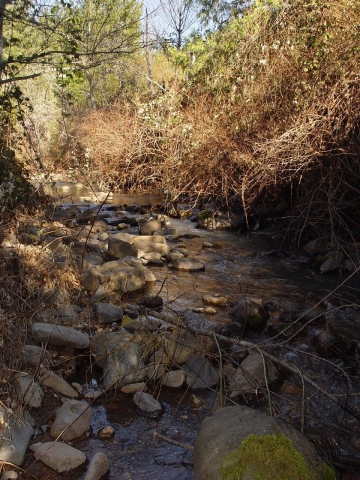 Stream morphological evidence.

 Stream morphological evidence
Anadromous fish, like salmon and steelhead trout, need specially sized stones and gravel to be able to do their nest building. Their nests are called redds. These materials were readily provided for them naturally when the stream was pristine and untouched. Modern forest management practices all but destroyed the streams ability to retain the needed aggregates for nest building. Because woody debris was removed from the streams and vegetation along the stream banks. Soon the streams became nothing but erosion gullies. The size of the rocks in the stream bed tells us a lot about the flow of the stream during winter months. It also makes a good “base line measurement” to determine if our instream restoration work is repairing the stream.

 Stream morphological evidence.

 Stream morphological evidence

 Stream morphological evidence
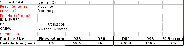
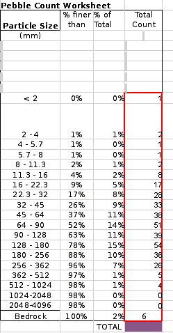
The aggregate size information above was taken from the stream bed on the lower end of the stream restoration project area. This information was used to make to help classify the stream's potential for stream rehabilitation. Large cobble stones and boulders like those above do not make good habitat for fish. They say,“The water is flowing too fast and steep”. Joe Hall Creek actually was considered borderline habitat except for one small detail. In the winter of 2004-2005 its fate was sealed by the return of several breeding pairs of Coho Salmon (Oncorhynchus kisutch). It wasn't always so with this stream. It would flow year around and host many young salmonids over the summer months. Hey, if it's good enough for the fish, it's good enough for me!

 Stream Profiling

 Stream Profiling

 Stream Profiling
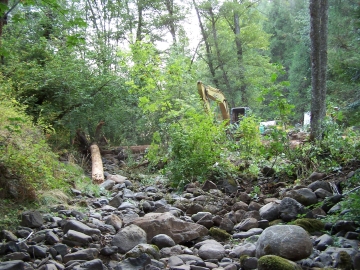
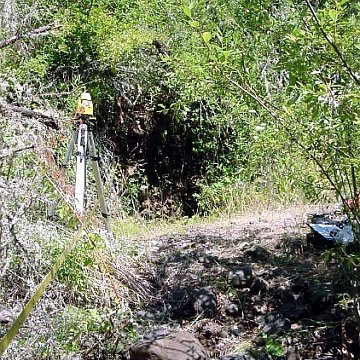
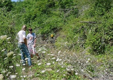
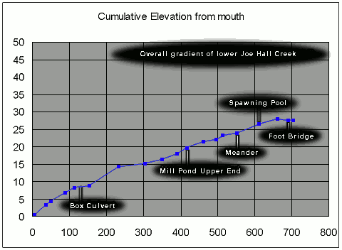
The next phase of information gathering centered on getting gradient and cross section profiles of the lower end of the stream. The images above are examples of our effort. Armed with machete', laser level and measuring rods our intrepid crew negotiated the brier patch thickets for a scientific assessment of the downcutting damage that had been done to the stream. This very same profile data was used to determine where and how many various instream structures would be needed to stabilize and reverse the stream damage.
The upper end of the stream did not receive the extensive delineations that this lower end needed. Nevertheless we did several cross section profiles on the upper end at strategic points to get a base line measurement for determining the amount of stream aggradation taking place as a result of the structure placements.

 Stream Profiling

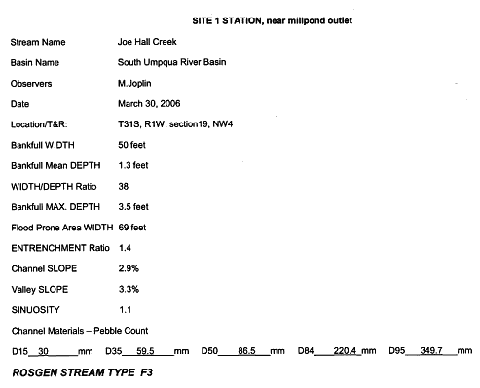
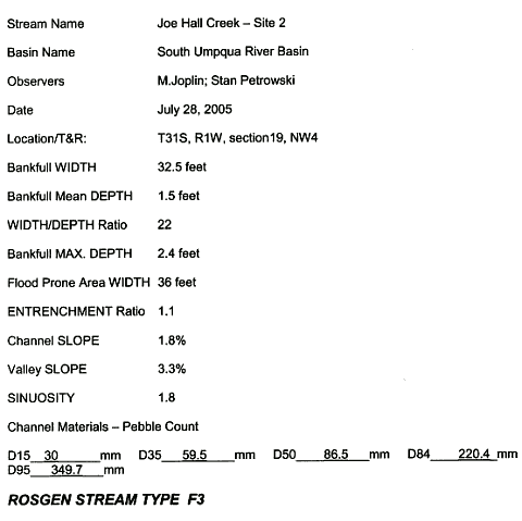
The above small image on the right is a link to a page that displays of chart of great value. It is know as the “The Key to the Rosgen Classification of Natural Rivers f”. It illustrates a system of stream and river classification based on a compendium of scientific information that helps us determine a streams potential. After putting our collected data together the mainstem of Joe Hall Creek is classified as Rosgen type B stream channel ranging from bedrock-dominated channels (B1) to cobble and gravel dominated channels (B3 and B4).
Modified channel reaches have become incised, exhibiting the near vertical banks of the F3 channel type Rosgen F3 class. The stream was not always to be found in that class. We are hoping that our efforts will make it more beneficial to its aquatic inhabitants as the stream takes on its historical condition. The fact that the endangered (listed again as of 2008) Coho Salmon have returned here spurs us on to use our resources to repair the breech in the salmon's life cycle.
Weir Site 1

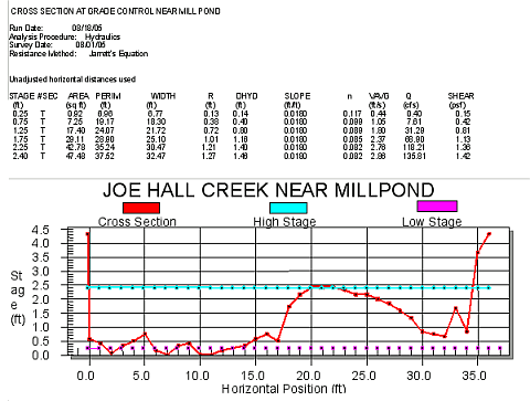
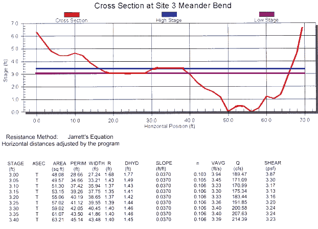
 Stream Cross Section
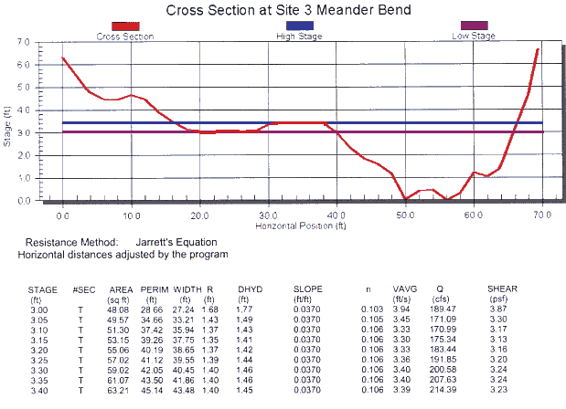
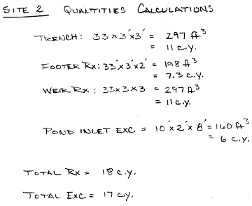
Here is the cross section for the first stone weir site. This graph contains a tremendous amount of information about this site. High flow stage, low flow stage and other elements that will impact the weir are contained therein.

 Stream Cross Section
After the accumulated data is sifted through by the weir designer it is given a Rosgen Stream Classification. The details of potential flooding effects and a baseline of information to mark site changes is contained in the above document.


 Stream Cross Section
Now the hydrologist is ready to do the design work. The height and width of the weir along with its general shape are predetermined by the stream morphology and the intended effects of the weirs construction on the stream. During the actual construction the laser level and measuring rod are always handy.
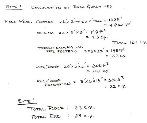
At this stage we are able to make the list of materials that will be needed to construct the weir.

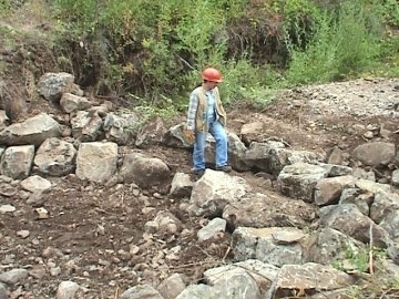
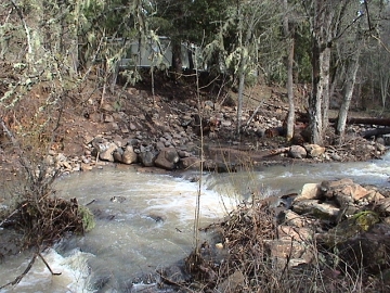
 Site 1 Weir

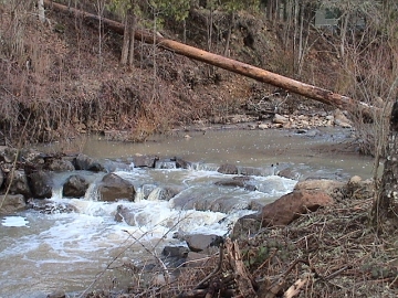
 First Year Results

 First Year Results
Weir at site one constructed and up and running. In the future we hope to have year around flow and pools of water at this site. Through the dynamics of scowering the pool depth and length should stabilize. Willow and tree planing along the bank will provide cover and shade for the young fingerlings.
Weir Site 2
The following images are a repeat performance of the process just review. They are set here for the record of the stream project. To get a better overview of each site development along the stream be sure to see our site index for coverage.

 First Year Results
 First Year Results

 First Year Results

 First Year Results

 First Year Results
Weir Site 3
A unique aspect of the site three was the need for the bank to be reinforced to prevent the collapse of portions of the land used to support a dwelling.

 First Year Results
 First Year Results

 First Year Results


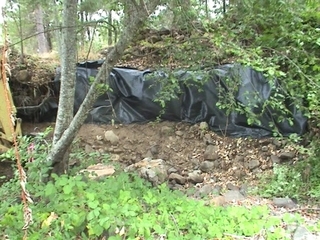 Bank Reinforcement with Reinforced Bank

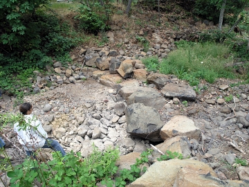 Rock Weir 3 with Reinforced Bank

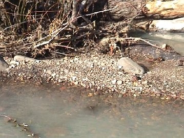
 Rock Weir 3
Some of the immediate end results are showing up already. There has been a consistent accumulation of aggregates for nest building . The willow and tree planting is producing slow growing results but there are definite signs of improvement. The following images tells the rest of the story. Below are images illustrating the capture of the all important nest building aggregate materials.

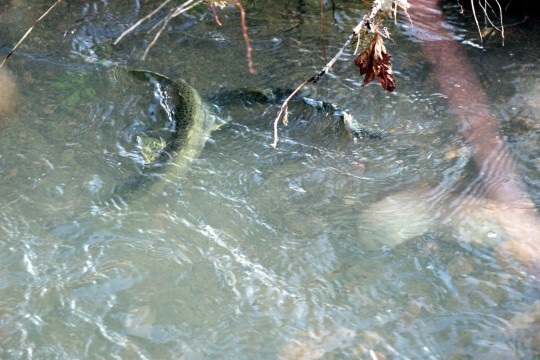 Spawning Steelhead at weir 2

 First Year Results

 First Year Results
We would be remiss not to acknowledge the main players designing, supervising and implementing the instream work here at Singing Falls and the Joe Hall Creek Aquatic Habitat Restoration Project

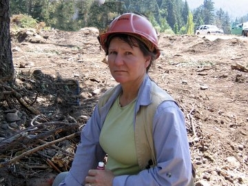 Maureen Joplin USFS Hydrologist
Maureen Joplin was the Tiller Ranger District Hydrologist at the time of our project. Her years of experience are well appreciated and evident as the project went forward. She skillfully negotiated the tasks at hand made crucial aspects of the project happen.

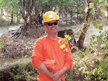 Casey Baldwin USFS Fish Biologist
Casey “C dog“ Baldwin is one of the USFS District Fish Biologists. It was his impetus and inspiration that got the project going in the first place. Casey took care of the logistics surrounding the delivery of men and materials to get the project done. He designed the log and weir placement for the rest of the remaining project sites.
Thanks Maureen and Casey for a job well done.
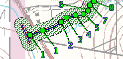 |
Click on a number or green dot above to view site images and information. Use your browser's back button to return here.
stream index
top


